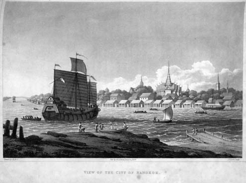
Historical Bangkok River View 1822
This remarkable historical illustration captures Bangkok's Chao Phraya River as it appeared in 1822, during the early Rattanakosin period under King Rama II. The detailed cityscape reveals the traditional wooden architecture and bustling river commerce that defined Bangkok before modern development transformed the riverfront.
In this rare historical perspective, traditional Thai houses on stilts line the riverbank, with numerous boats navigating the waters that served as Bangkok's primary transportation network. The image provides invaluable insight into how the Chao Phraya River shaped daily life in 19th-century Siam, when waterways functioned as the city's main streets and commercial arteries.
|
|
|
|
📚 Historical Context:
• Period: Early Rattanakosin Era (King Rama II reign)
• Significance: Shows Bangkok before modern development
• Architecture: Traditional wooden houses on stilts
• Transportation: River-based commerce and travel system
• Period: Early Rattanakosin Era (King Rama II reign)
• Significance: Shows Bangkok before modern development
• Architecture: Traditional wooden houses on stilts
• Transportation: River-based commerce and travel system